


GPS area measure - land survey
وصف لـGPS area measure - land survey
Want to know the true size of your land?
Measure the perimeter of a field?
Determine the exact position of that border stone?
Collect GPX-data and visualize at home?
How to use:
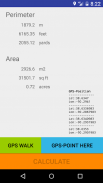
Simply press the green button "GPS WALK" and start walking.
Now walk along the border of the area.
If there is any obstruction just press "PAUSE" and move on to the next accessible point.
Continue with "GPS WALK" or "GPS POINT HERE".
Once you are done click "CALCULATE" and the app will determine the area and perimeter.
The last position will automatically connect with the first position so you do not need to worry about closing the area exactly.
For convenience, area and perimeter are presented in imperial and metric units,
"m2", "acre", "squarefeet" for areas and "m", "feet" and "yards" for perimeters.
Now you can send the GPS-data via email to your (or other peoples) mail-account.
Cut the GPX-part and paste it into one of the many GPS-visualizers available on the Internet.
How it works:
The app strictly follows the WGS84-model to transfer Latitude- and Longitude-data to metric distances between waypoints.
WGS84 is currently the reference system being used by the Global Positioning System.
It originally used the GRS 80 reference ellipsoid, but has undergone some minor refinements in later editions since
its initial publication. WGS 84 uses the EGM96 (Earth Gravitational Model 1996) geoid, revised in 2004.
This geoid defines the nominal sea level surface by means of a spherical harmonics series of
degree 360 (which provides about 100 km latitudinal resolution near the Equator).
Permissions needed:
android.permission.ACCESS_FINE_LOCATION
android.permission.ACCESS_COARSE_LOCATION
android.permission.ACCESS_LOCATION_EXTRA_COMMANDS
android.permission.LOCATION_HARDWARE
this app will:
- measure acreage
- convert acres to square feet (internal)
- assists in land survey
- measure the total distance of your waypoints
- calculate perimeter
- area measurement
- fields area measure
- gps walk
نريد أن نعرف الحجم الحقيقي للأرضكم؟
قياس محيط الميدان؟
تحديد الموضع الدقيق من هذا الحجر الحدود؟
جمع GPX البيانات وتصور في المنزل؟
كيف تستعمل:
ببساطة اضغط على الزر الأخضر "GPS WALK" والبدء في المشي.
الآن السير على طول الحدود في المنطقة.
إذا كان هناك أي عائق فقط اضغط على "وقفة" والانتقال إلى نقطة الوصول المقبلة.
تواصل مع "WALK GPS" أو "GPS POINT HERE".
بمجرد الانتهاء من ذلك انقر على "حساب" وسوف التطبيق تحدد منطقة ومحيط.
وموقف آخر اتصال تلقائيا مع المركز الأول لذلك كنت لا داعي للقلق حول إغلاق المنطقة تماما.
للراحة، ويتم عرض منطقة ومحيط في وحدات الامبراطورية ومتري،
"M2"، "فدان"، "squarefeet" للمناطق و "م"، "قدم" و "ساحات" للمحيط.
الآن يمكنك إرسال البيانات GPS عبر البريد الإلكتروني إلى الإلكتروني حسابك (أو الشعوب الأخرى).
قطع GPX-جزء ولصقه في واحدة من العديد من GPS-متخيلون المتاحة على شبكة الإنترنت.
كيف تعمل:
التطبيق يتبع بدقة WGS84 نموذج لنقل Latitude- وخط الطول البيانات لمسافات متري بين نقاط الطريق.
WGS84 حاليا النظام المرجعي المستخدمة من قبل نظام تحديد المواقع العالمي.
وهي تستخدم في الأصل الإهليلجي إشارة GRS 80، ولكن شهدت بعض التحسينات الطفيفة في طبعات لاحقة منذ
نشر الأولي. WGS 84 يستخدم EGM96 (الأرض الجاذبية نموذج 1996) الجيود، المنقحة في عام 2004.
ويعرف هذا الجيود سطح الاسمي مستوى سطح البحر عن طريق سلسلة التوافقيات كروية ل
360 درجة (والذي يوفر نحو 100 كلم قرار خطوط العرض القريبة من خط الاستواء).
الأذونات المطلوبة:
android.permission.ACCESS_FINE_LOCATION
android.permission.ACCESS_COARSE_LOCATION
android.permission.ACCESS_LOCATION_EXTRA_COMMANDS
android.permission.LOCATION_HARDWARE
هذا التطبيق سوف:
- مساحة التدبير
- تحويل فدان لقدم مربع (الداخلية)
- يساعد في مسح الأراضي
- قياس المسافة الإجمالية من النقاط الخاصة بك
- محيط حساب
- قياس منطقة
- حقول قياس منطقة
- تحديد المواقع المشي
GPS area measure - land survey - إصدار 1.14
(26-02-2020)GPS area measure - land survey - معلومات APK
نُسخة APK: 1.14الحزمة: com.sekora.deviceloc1آخر إصدار من GPS area measure - land survey
نُسخ أخرى


تطبيقات من الفئة نفسها

قد يعجبك أيضًا...


